Butterflies in High Line Park

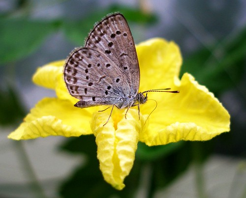
Butterfly on a yellow flower by tanakawho

Whenever I see a butterfly, I get so excited, I am like a child. What is the wonder of butterflies that make them so magical?  Bear with TheGardenLady as I share a favorite poem or skip to the bottom to read about Manhattan’s newest park.

“To A Butterfly” (1801)
I’VE watched you now a full half-hour;
Self-poised upon that yellow flower
And, little Butterfly! indeed
I know not if you sleep or feed.
How motionless!–not frozen seas
More motionless! and then
What joy awaits you, when the breeze
Hath found you out among the trees,
And calls you forth again!

This plot of orchard-ground is ours;
My trees they are, my Sister’s flowers;
Here rest your wings when they are weary;
Here lodge as in a sanctuary!
Come often to us, fear no wrong;
Sit near us on the bough!
We’ll talk of sunshine and of song,
And summer days, when we were young;
Sweet childish days, that were as long
As twenty days are now.
________________________

STAY near me–do not take thy flight!
A little longer stay in sight!
Much converse do I find in thee,
Historian of my infancy!
Float near me; do not yet depart!
Dead times revive in thee:
Thou bring’st, gay creature as thou art!
A solemn image to my heart,
My father’s family!
Oh! pleasant, pleasant were the days,
The time, when, in our childish plays,
My sister Emmeline and I
Together chased the butterfly!
A very hunter did I rush
Upon the prey:–with leaps and springs
I followed on from brake to bush;
But she, God love her, feared to brush
The dust from off its wings.

By William Wordsworth (1770-1850).
_______________________________

Today I saw the second Monarch butterfly this summer. I wasn’t certain the first butterfly I saw yesterday was really a Monarch because it flitted away from me so quickly. Then I spoke to a friend who saw a Monarch flying when she was walking on the High Line in Manhattan a few weeks ago. So I knew that the Monarch butterflies are starting to migrate in my area.

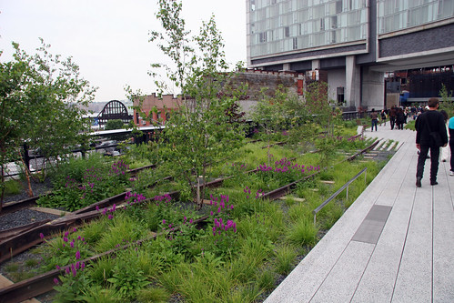
090610 High Line Park 017 by joevare

If you don’t know about the High Line and love walking in gardens then you are in for a treat if you visit Manhattan. It is the newest park. Located on Manhattan’s West Side, it runs from Gansevoort Street in the Meatpacking District to West 34th Street, between 10th & 11th Avenues. Section 1 of the High Line opened to the public on June 9, 2009 and the rest just opened June 8, 2011.The park is filled with native plants. Check out their website where you can get a list of the native plants they planted and which plants are in bloom each month.  See here.

Downloads of Nature Walks

What can you do when you can’t get out into your garden?

Our friends at How to Cope with Pain wrote this week about a website Peaceful Walks, which offers downloads of nature “walks” for sale.  As How to Cope with Pain says, these won’t replace getting out into your garden or the outdoors, but they are beautiful photography and relaxing to watch.  Here is a review.

Castle Rock State Park – Part II

Climbing at Castle Rock State Park by ...Rachel J..

This is the second post in a series about the geology of Castle Rock State Park.  It was submitted by a reader named Jonathan.  In the first post, Jonathan explained why he chose to write about Castle Rock State Park and he also showed where it’s located.  In this post, Jonathan will discuss the geologic history of the park.

According to geologist Richard Stanley, the rock formations of Castle Rock State Park are a component of the tertiary strata of La Honda basin, a “marine embayment that persisted through much of Tertiary time in the area of the modern Santa Cruz Mountains.” In his paper, ‘Evolution of the Tertiary La Honda Basin, Central California’ (1990), Stanley summarizes the history of this area:

The complicated geology and geologic history of the La Honda basin reflect the fact that, throughout its history, the basin has been located at or near the tectonically active plate boundary between the North American continent and various oceanic plates of the Pacific basin. The La Honda basin originated during the Paleocene, perhaps during an episode of wrench tectonism associated with oblique subduction and arrival of the Salinia terrane. Major restructuring of the basin during the Oligocene—including uplift and erosion of the basin margins, movement along the Zayante-Vergeles fault, and deposition of two sand-rich deep-sea fans—apparently resulted from the approach of the Farallon-Pacific spreading ridge and its collision with the California continental margin. During the late Oligocene and early Miocene, widespread volcanism and marine transgression accompanied an episode of regional transtension along the San Andreas fault system. Deposition of shallow marine sandstones and deeper-water siliceous mudstones occurred during much of the Miocene and Pliocene but was interrupted at least three times by brief episodes of uplift and erosion associated with transpressional wrench tectonism along the San Andreas fault. Marine deposition ended and uplift of the modern Santa Cruz Mountains began during the late Pliocene in response to the most-recent episode of regional transpression.

Stanley refers to ‘sand-rich deep-sea fans,’ which, in ‘A Dictionary of Earth Sciences’ (A. Allaby & M. Allaby, 1999) is defined as a “fan-shaped body of sediment that accumulates at the lower end of a submarine canyon, either at the foot of the continental slope or on the continental rise” (figure 4). In other words, a deep-sea fan can be thought of as an underwater version of alluvial fan.

Figure 4

According to Stanley, the sandstone, mudstone and conglomerate that were deposited by these deep-sea fans formed sedimentary rock, which was uplifted in the Santa Cruz Mountains as Vaqueros Sandstone that we see today in Castle Rock State Park.

Geologic maps of Castle Rock State Park and the surrounding region indicate that most of the Park’s outcrops are Vaqueros Sandstone (figure 5).

Figure 5

Additionally, because fossils contained within sedimentary rocks vary from the bottom to the top of layers, fossils found within the Park’s outcrops allow geologists to date the rock to be approximately 23 million years old (figure 6).

Figure 6

Castle Rock State Park – Part I

"Easter at Castle Rock" 28. by Madonovan

This is the first post in a series about the geology of Castle Rock State Park.  It was submitted by a reader named Jonathan.  In this post, he explains why he writes about Castle Rock State Park and where it’s located.  In the next post, Jonathan will discuss the geologic history of the park.

I chose to write about Castle Rock State Park because of its unique rock  formations, including the Park’s namesake, Castle Rock.  These formations are most dramatic near the Park’s main entrance where, in addition to Castle Rock, you can find Castle Rock Falls and Goat Rock. The Park’s attractions are not limited to its geology; its 35 miles of trails for hiking, rock climbing, camping, and spectacular views of the San Lorenzo Valley and Pacific Ocean are also major draws. Moreover, the Park’s close proximity to Stanford and the Greater San Jose Area makes it a regular destination for afternoon visits.

The Park’s most popular hike—a 6-mile loop along the Saratoga Gap Trail and Ridge Trail—pass and climb over the above-mentioned formations as well as numerous other outcroppings. The following review of Castle Rock State Park’s Geology covers 5 general regions of the park (figure 1):

1. Castle Rock and Surrounding Outcroppings

2. Castle Rock Falls and the Falls Overlook

3. Outcroppings along Saratoga Gap Trail

4. Outcroppings along Ridge Trail

5. Goat Rock

Where is Castle Rock State Park:

Castle Rock State Park is sandwiched between CA-35 and CA-9 in Los Gatos, CA; roughly 20 miles south of Stanford University (figure 2).  From Stanford, travel approximately 11.5 mile south on Page Mill Road to CA- 35/Skyline Blvd, and then travel just under 9 miles south on CA-35/Skyline Blvd to the Park’s main entrance, which is on the west side of the road. Many of the Park’s trails and dirt roads are also accessible further north on CA-35 and along CA-9.

Castle Rock State Park is adjacent to several other parks, including—from east to west—Sanborn Skyline Country Park, Saratoga Gap Open Space Preserve, Long Ridge Open Space Preserve, and Big Basin Redwoods State Park. Accordingly, many of Castle Rock’s geologic features are similar to those in nearby parks.

The featured 6-mile loop hike along the Ridge and Saratoga Gap Trails covers the western and central parts of the park (figure 3). The elevation of this region ranges from 2,600 feet to 3,200 feet above sea level.